No specific info about version 4.2. Please visit the main page of Lidar Analyst for ArcGIS on Software Informer.
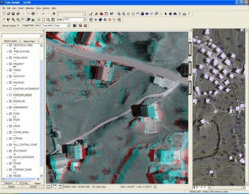
ArcGIS extension with geospatial analysis capabilities for mlitary applications.
It is a set of tools for ArcGIS that enable the users to create surfaces.
You can view an image service using various client applications.
Geospatial mapping and analysis tool with ESRI file support.
Predictor Analyst has advanced GIS-like functionality for organising noise maps


Comments