Lidar Analyst for ArcGIS 5.0
Trusted Download
98.6 MB

Lidar Analyst for ArcGIS 5.0

The LIDAR Analyst® software extracts 3D objects from airborne LIDAR data, unlocking its value for geospatial analysis
4 
Rating
Your vote:
Latest version:
5.0.0001 See all
Developer:
Screenshots
1 / 1
Awards (1)
Show all awards
Software Informer Virus Free award
Trusted Download
98.6 MB

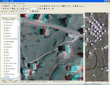
LIDAR Analyst for ArcGIS is a 3D feature extraction software extension designed to help geospatial analysts unlock the value of airborne LIDAR (Light Detection and Ranging) data by automatically extracting 3D objects such as bare earth, trees, or buildings.

Comments

5 stars
1
4 stars
0
3 stars
1
2 stars
0
1 stars
0
User

Your vote:

Suggestions

  • Lidar analyst free
  • Lidar analyst for arcgis 4.2
  • Feature analyst
  • Lidar analyst 4.2 download
  • Lidar analyst extension for arcgis
  • Feature analyst arcgis app
  • Lidar analyst 4.2
  • Lidar analyst arcgis
  • Download military analyst 10